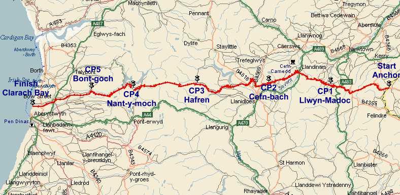
The Route, Maps and GPS
Maps
Whilst Landranger 135 and 136 maps cover the entire route, it is highly recommended that the following 1:25,000 maps be used for navigation:
- Explorer 213 Aberystwyth and Cwm Rheidol
- Explorer 214 Llanidloes and Newtown
Note that the carrying of maps covering the whole route is a mandatory requirement. See The Event in Detail for further information on essential equipment which must be carried.
Checkpoints
Note that all checkpoints must be visited, but entrants are free to choose their own route.
CP |
OS Explorer (Landranger)
|
Location |
Open time |
Close time |
Section (miles) |
Total (miles) |
Start |
214 (136) |
Anchor Bridge | - |
0500 |
- |
0 |
1 |
214 (136) |
Llwyn-Madoc | 0600 |
0830 |
8.3 |
8.3 |
2 |
214 (136) |
Cefn-bach | 0745 |
1130 |
8.3 |
15.8 |
3 |
214 (135) |
Hafren picnic site | 0930 |
1430 |
9.0 |
24.8 |
4 |
213 (135) |
Nant-y-moch dam | 1100 |
1800 |
8.7 |
33.5 |
5 |
213 (135) |
Bont-goch (Elerch) | 1200 |
2030 |
5.6 |
39.1 |
Finish |
213 (135) |
Clarach Bay | 1300 |
2300 |
6.7 |
45.8 |
Route Descriptions
Route descriptions for the Across Wales Walk will be sent out to entrants a week or so before the event. Should you require to recce the route beforehand – highly recommended for those new to the event – previous editions are available on request. Entrants must determine suitability of the route in relation to their own abilities. No liability for error, accident or any other arising is accepted or implied.
GPS Coordinates
GPS coordinates for the Across Wales Walk in GPX format will be sent out to entrants a week or so before the event. As with route descriptions, previous editions are available on request.
Entrants must determine suitability of the route in relation to their own abilities. No liability for error, accident or any other arising is accepted or implied.